- City and Installation Guide
- City Listings (new)
- Bottomless Lakes State Park
Bottomless Lakes State Park

City Listings
Geographical Address
Business Info
- Mon 6:00 am - 9:00 pm Closed now
- Tue 6:00 am - 9:00 pm
- Wed 6:00 am - 9:00 pm
- Thu 6:00 am - 9:00 pm
- Fri 6:00 am - 9:00 pm
- Sat 6:00 am - 9:00 pm
- Sun 6:00 am - 9:00 pm
Bottomless Lakes State Park is a state park in the U.S. state of New Mexico, located along the Pecos River, about 15 miles (24 km) southeast of Roswell. Established in 1933, it was the first state park in New Mexico. It takes its name from nine small, deep lakes located along the eastern escarpment of the Pecos River valley.
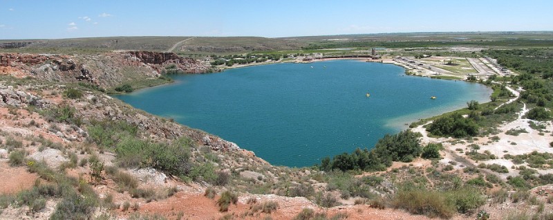
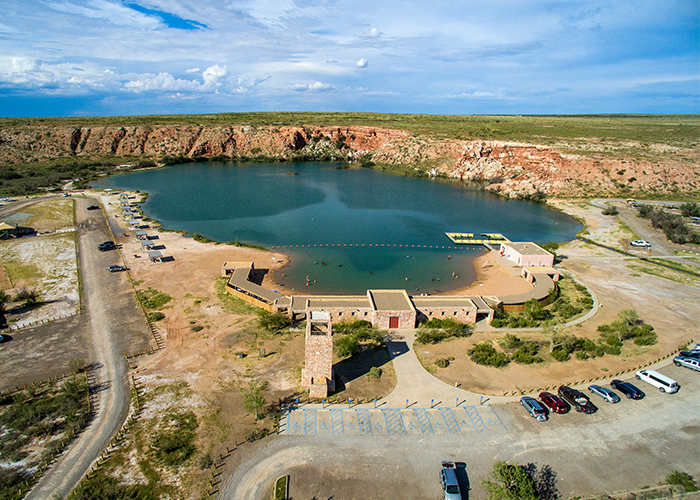
Most of the nine lakes are almost completely surrounded by cliffs, with the notable exceptions being Lea Lake and Lazy Lagoon. Lea Lake has a large, sandy shoreline on the western side and tall cliffs on the eastern side. The cliffs around Lazy Lagoon have been completely eroded away by the Pecos River, and the lake sits in a former channel of the river.
Lazy Lagoon is the largest of the lakes, with a surface area of approximately 26.1 acres (10.6 ha). Although it is a single lake, it is made up of three separate sinkholes. The surface of the Lazy Lagoon is nearly level with the surrounding salt flats, which makes it look very shallow. Despite the name, the deepest of its three sinkholes is 90 feet (27 m) deep.
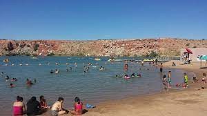
Lea Lake is the only lake in which swimming is allowed. It has a beach and concession area that is popular in the summer.
Devil's Inkwell is the smallest lake with a surface area of 0.36 acres (0.15 ha). Its name stems from the water's dark color, caused by the steep sides of the cenote and algae growth within the lake.
In pure geologic terms, Figure Eight Lake is two lakes separated by a thin strip of land. When the water is very high the strip of land is covered, and the two nearly circular lakes join and take the shape of figure eight. Irrigation in the Pecos Valley has lowered the water table, so the two lakes of Figure Eight lake rarely join to form a single lake anymore.
Pasture Lake is the shallowest lake at 18 feet (5.5 m) deep with a surface area of 0.76 acres (0.31 ha).
Activities
- Boating:
- Non-motorized
- Canoe/Kayak/Board
- Camping
- Education Programs
- Fishing (November – March)
- Picnicking
- Scuba Diving
- Swimming
- Trails:
- 53 total miles
- Interpretive/Accessible
- Skidmarks mountain bike trail – 3.13 mi
- The Bluff Trail – .86 mi
- The Wetlands Trail – .54 mi
- Wildlife Viewing:
- Birding
Amenities
- Rental Facilities:
- Pedal Boat/Paddle Board/Lifejacket rentals (Memorial Day weekend – Labor Day weekend)
- Lea Lake Campground Facilities
- 32 total campsites with hook-ups
- 6 full hook-up campsites, 26 sites with water/electric hook-ups
- RV Dump Station
- Group Shelter
- Restrooms with showers
- Lea Lake Day-Use Area Facilities:
- Beach
- Playground
- Sand Volleyball Court
- Restrooms (seasonal closure)
- Outdoor Shower Towers (seasonal closure)
- Group Shelter
- 24 Picnic Shelters
- Historic Lea Lake Pavilion
- Lower Lakes Area:
- 10 Developed Campsites
- Vault Toilets
- Visitor Center
- Exhibits/Park Information
- Wildlife Viewing Blinds

Map
-
{{#owner}}
-
{{#url}}
{{#avatarSrc}}
{{name}} {{/url}} {{^url}} {{#avatar}} {{& avatar}} {{/avatar}} {{name}} {{/url}} - {{/owner}} {{#created}}
- {{created}} {{/created}}