Abuyog
Geographical Address

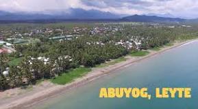
Abuyog, officially the Municipality of Abuyog, is a 1st class municipality in the province of Leyte, Philippines. According to the 2015 census, it has a population of 59,571 people.[3]
Facing Leyte Gulf out into the Philippine Sea, it is the largest town of the island of Leyte in terms of land area. It is bordered to the north by Javier, to the east by Mahaplag and Baybay City and to the south by Silago in Southern Leyte.
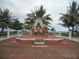
Abuyog got its name when Spanish sailors came ashore in an early settlement at the mouth of the Abuyog River to replenish their supplies. Swarms of bees were all over the shore. The Spaniards asked the natives "¿Cómo se llama el pueblo?", not knowing that the Spaniards asked for the town's name, the natives answered "Buyog". Repeating after the natives, the sailors muttered, "Ah! Buyog". Eventually the town came to be known as "Abuyog" to which some Spanish chroniclers often used in reference to the whole island of Leyte. But Abuyog in the early annals, though grown prosperous, remained obscure because of the absence of a powerful chieftain. It was Datu Bangcao, who had his seat of government in Carigara, who ruled Abuyog.
People mostly from Samar migrated to Abuyog because of the many opportunities the immigrants got from its rich soil. The language of this town which acquired the name "melting pot" became Waray-Waray language from the Samar immigrants.
https://en.wikipedia.org/wiki/Abuyog,_Leyte

Map
-
{{#owner}}
-
{{#url}}
{{#avatarSrc}}
{{name}} {{/url}} {{^url}} {{#avatar}} {{& avatar}} {{/avatar}} {{name}} {{/url}} - {{/owner}} {{#created}}
- {{created}} {{/created}}
