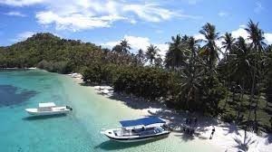
Agutaya
Hot
E
elie
Updated
Geographical Address
Country
Province
City
Public Address
Agutaya, Palawan
Postal Code
5320
latitude
11.23
longitude
120.94
Area
37.31 km2
Division
Luzon
Region
IV-B

Agutaya, officially the Municipality of Agutaya, is a 5th class municipality in the province of Palawan, Philippines. According to the 2015 census, it has a population of 12,545 people.[3]
An island municipality, it is the eastern part of the Cuyo Archipelago in the Sulu Sea, and the municipality covers several islands, including its namesake Agutaya Island, which is the second largest island of the Cuyo archipelago,[4]as well as Diit, Halog, Maracanao, Matarawis (also spelled Matarabis), Oco, and Quiniluban islands.
https://en.wikipedia.org/wiki/Agutaya
Map
{{#ratings}}
{{title}}
{{#ownerCreatedBlock}}
{{/ownerCreatedBlock}}
{{#category}}
{{#editor}}
{{/editor}}
{{#user}}
{{/user}}
{{/ratings}}
-
{{#owner}}
-
{{#url}}
{{#avatarSrc}}
{{name}} {{/url}} {{^url}} {{#avatar}} {{& avatar}} {{/avatar}} {{name}} {{/url}} - {{/owner}} {{#created}}
- {{created}} {{/created}}
Category: {{category.title}}
{{/category}}
{{#fields}}
{{#showLabel}}
{{/fields}}
{{label}}:
{{/showLabel}}
{{& text}}


