Bani
E
elie
Updated
Geographical Address
Country
Province
City
Postal Code
2407
latitude
16.22
longitude
119.86
Area
179.65 km2
Founded
1769
Division
Luzon
Region
Region 1

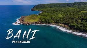
Bani, officially the Municipality of Bani, (Pangasinan: Baley na Bani; Ilokano: Ili ti Bani; Tagalog: Bayan ng Bani), is a 2nd class municipality in the province of Pangasinan, Philippines. According to the 2015 census, it has a population of 50,306 people.[3] It is located between Alaminos City and Bolinao and is named after the Bani, tree which could be found in the Poblacion. Dubbed as the "Golden West" in the 1960s and early 1970s, Bani lies between Tambac Bay and West Philippine Sea.[6] Bani has a land area of 19,243.6075 hectares.
https://en.wikipedia.org/wiki/Bani,_Pangasinan

Map
{{#ratings}}
{{title}}
{{#ownerCreatedBlock}}
{{/ownerCreatedBlock}}
{{#category}}
{{#editor}}
{{/editor}}
{{#user}}
{{/user}}
{{/ratings}}
-
{{#owner}}
-
{{#url}}
{{#avatarSrc}}
{{name}} {{/url}} {{^url}} {{#avatar}} {{& avatar}} {{/avatar}} {{name}} {{/url}} - {{/owner}} {{#created}}
- {{created}} {{/created}}
Category: {{category.title}}
{{/category}}
{{#fields}}
{{#showLabel}}
{{/fields}}
{{label}}:
{{/showLabel}}
{{& text}}
