- City and Installation Guide
- City Listings (new)
- Cleveland National Forest
Cleveland National Forest
City Listings
Geographical Address
Contact Info
Business Info
- Mon 8:00 am - 4:30 pm
- Tue 8:00 am - 4:30 pm Open now
- Wed 8:00 am - 4:30 pm
- Thu 8:00 am - 4:30 pm
- Fri 8:00 am - 4:30 pm
- Sat Closed
- Sun Closed
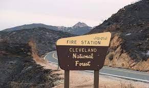
The Cleveland National Forest honors its past and celebrates all it has to offer visitors. The Forest provides various terrains and recreational opportunities, including camping and picnic areas, hiking, exploring on horseback, trail running, mountain biking, and scenic drives.
The Cleveland National Forest is the southernmost National Forest in California. Consisting of 460,000 acres (720 sq mi) (1,900 km), the forest offers a wide variety of terrains and recreational opportunities.
Until the arrival in San Diego of Juan Rodriguez Cabrillo, the lands now within the Cleveland National Forest were known only to the desert and coastal Indian tribes who used them. The Kumeyaay, Luiseños, Cahuilla, and Cupeño found a good living on the abundant acorns and game. Many of our trails today follow those routes first used by these early dwellers.
Created on July 1, 1908, with the consolidation of the Trabuco Canyon National Reserve and San Jacinto National Reserve by President Theodore Roosevelt and named after former president Grover Cleveland. The Forest is divided into the Trabuco, Palomar, and Descanso Ranger Districts and is located in the counties of Riverside, Orange, and San Diego.
Map
-
{{#owner}}
-
{{#url}}
{{#avatarSrc}}
{{name}} {{/url}} {{^url}} {{#avatar}} {{& avatar}} {{/avatar}} {{name}} {{/url}} - {{/owner}} {{#created}}
- {{created}} {{/created}}


