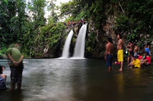
Kalayaan
Geographical Address

Kalayaan, officially the Municipality of Kalayaan, (Tagalog: Bayan ng Kalayaan), is a 3rd class municipality in the province of Laguna, Philippines. According to the 2015 census, it has a population of 23,269 people.[3]
Kalayaan is roughly rectangular in shape, with a hilly terrain on most of its eastern side, while relatively flat on its western side. Its highest elevations are from 400 to 418 metres. These are found in Sitio Santo Angel, Malaking Pulo, and Cabuhayan in Barangay San Juan, and Sitio Lamao in Barangay San Antonio. Approximately three fourths of the total land area are with terrain 300 metres above sea level. Its lowest points are from 5 to 20 metres along the western sections of Barangays San Juan and Longos towards Laguna de Bay.
The municipality was formerly called Longos until 1956 when it was changed to its present name.
https://en.wikipedia.org/wiki/Kalayaan,_Laguna
Map
-
{{#owner}}
-
{{#url}}
{{#avatarSrc}}
{{name}} {{/url}} {{^url}} {{#avatar}} {{& avatar}} {{/avatar}} {{name}} {{/url}} - {{/owner}} {{#created}}
- {{created}} {{/created}}


